
Fichier:VOC Octrooigebied 2.jpg

Taille de cet aperçu : 800 × 527 pixels. Autres résolutions : 320 × 211 pixels | 640 × 422 pixels | 1 024 × 675 pixels | 1 280 × 844 pixels | 3 000 × 1 978 pixels.
Fichier d’origine (3 000 × 1 978 pixels, taille du fichier : 663 kio, type MIME : image/jpeg)
Ce fichier et sa description proviennent de Wikimedia Commons.
Description
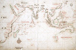
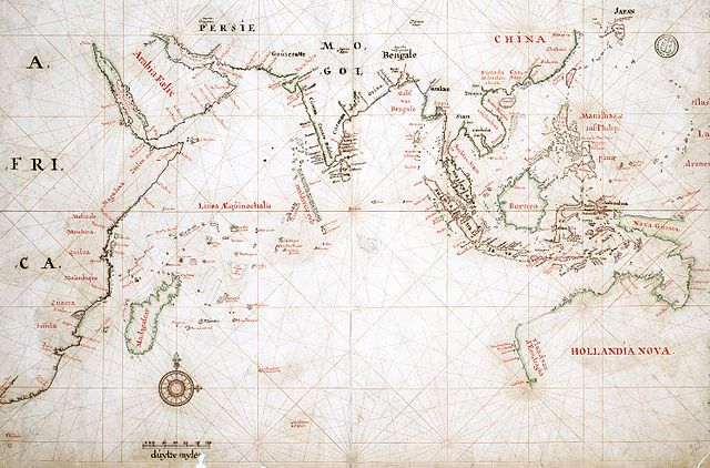
| Description | Map of the actual trade zone (octrooigebied) of the VOC, between Cape of Good Hope (South Africa) and Japan; c. 1665. The VOC establishments are marked with yellow dots and names in black. |
| Date | |
| Source | TANAP |
| Auteur |
Conditions d’utilisation
|
Cette œuvre est également dans le domaine public dans tous les pays pour lesquels le droit d’auteur a une durée de vie de 100 ans ou moins après la mort de l’auteur. | |
| Ce fichier a été identifié comme étant exempt de restrictions connues liées au droit d’auteur, y compris tous les droits connexes et voisins. | |
Historique du fichier
Cliquer sur une date et heure pour voir le fichier tel qu'il était à ce moment-là.
| Date et heure | Vignette | Dimensions | Utilisateur | Commentaire | |
|---|---|---|---|---|---|
| actuel | 3 mai 2008 à 12:33 | | 3 000 × 1 978 (663 kio) | BoH | {{Information |Description=Map of the actual trade zone (octrooigebied) of the VOC, between Cape of Good Hope (South Africa) and Japan; c. 1665. The VOC establishments are marked with yellow dots and names in black. |Source=[http://www.tanap.net/content/v |
Utilisation du fichier
La page suivante utilise ce fichier :
Usage global du fichier
Les autres wikis suivants utilisent ce fichier :
- Utilisation sur de.wikipedia.org
- Utilisation sur fy.wikipedia.org
- Utilisation sur lt.wikipedia.org
- Utilisation sur nl.wikipedia.org