
Fichier:Kessel von Cholm - Karte.png
Taille de cet aperçu : 432 × 600 pixels. Autres résolutions : 173 × 240 pixels | 346 × 480 pixels | 923 × 1 281 pixels.
Fichier d’origine (923 × 1 281 pixels, taille du fichier : 512 kio, type MIME : image/png)
Ce fichier et sa description proviennent de Wikimedia Commons.
Description
| Description |
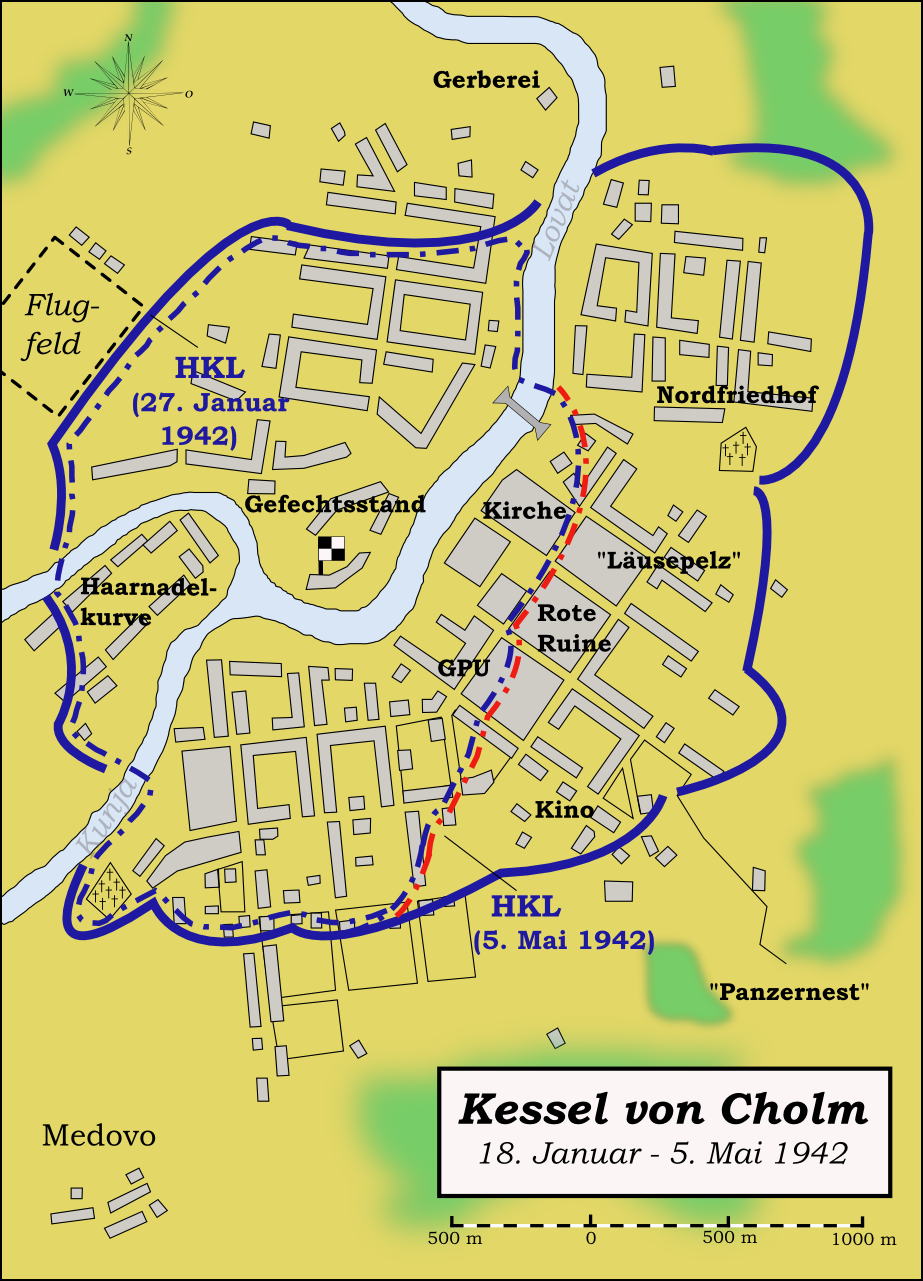
English: Map (in German language) showing the pocket of Kholm (January - May 1942) during the German-Soviet War 1941-1945. Hrvatski: Okruženje kod Holma - karta. Русский: Холмский котел - карта. Deutsch: Kessel von Cholm - Karte. |
| Date | |
| Source | Own work by uploader, based on different maps as sources, mainly from Otto Karsten: Cholm, 1944 (= Schriftenreihe zur Truppenbetreuung, Bd.55) and Richard Muck: Kampfgruppe Scherer - 105 Tage eingeschlossen, Gerhard Stalling Verlag, Oldenburg 1943. |
| Auteur | Memnon335bc |
Conditions d’utilisation
Moi, en tant que détenteur des droits d’auteur sur cette œuvre, je la publie sous les licences suivantes :
Ce fichier est disponible selon les termes de la licence Creative Commons Attribution – Partage dans les Mêmes Conditions 3.0 (non transposée).
- Vous êtes libre :
- de partager – de copier, distribuer et transmettre cette œuvre
- d’adapter – de modifier cette œuvre
- Sous les conditions suivantes :
- paternité – Vous devez donner les informations appropriées concernant l'auteur, fournir un lien vers la licence et indiquer si des modifications ont été faites. Vous pouvez faire cela par tout moyen raisonnable, mais en aucune façon suggérant que l’auteur vous soutient ou approuve l’utilisation que vous en faites.
- partage à l’identique – Si vous modifiez, transformez, ou vous basez sur cette œuvre, vous devez distribuer votre contribution sous la même licence ou une licence compatible avec celle de l’original.

|
Vous avez la permission de copier, distribuer et modifier ce document selon les termes de la GNU Free Documentation License version 1.2 ou toute version ultérieure publiée par la Free Software Foundation, sans sections inaltérables, sans texte de première page de couverture et sans texte de dernière page de couverture. Un exemplaire de la licence est inclus dans la section intitulée GNU Free Documentation License. |
Vous pouvez choisir l’une de ces licences.
Historique du fichier
Cliquer sur une date et heure pour voir le fichier tel qu'il était à ce moment-là.
| Date et heure | Vignette | Dimensions | Utilisateur | Commentaire | |
|---|---|---|---|---|---|
| actuel | 12 août 2009 à 03:25 | | 923 × 1 281 (512 kio) | Memnon335bc | Maßstab ergänzt |
| 6 février 2009 à 02:17 |  | 923 × 1 281 (506 kio) | Memnon335bc | == Summary == {{Information |Description={{en|1=Map (in German language) showing the pocket of Kholm (Januar - May 1942) during the German-Soviet War 1941-1945.}} |Source=Own work by uploader, based on different maps as sources, mainly from Otto Karsten: | |
| 4 janvier 2009 à 21:04 |  | 923 × 1 281 (508 kio) | Memnon335bc | {{Information |Description={{en|1=Map (in German language) showing the pocket of Kholm (Januar - May 1942) during the German-Soviet War 1941-1945.}} |Source=Own work by uploader, based on different maps as sources, mainly from Otto Karsten: ''Cholm, 1944' |
Utilisation du fichier
La page suivante utilise ce fichier :
Usage global du fichier
Les autres wikis suivants utilisent ce fichier :
- Utilisation sur ar.wikipedia.org
- Utilisation sur de.wikipedia.org
- Utilisation sur en.wikipedia.org
- Utilisation sur es.wikipedia.org
- Utilisation sur fi.wikipedia.org
- Utilisation sur ja.wikipedia.org
- Utilisation sur pl.wikipedia.org
- Utilisation sur th.wikipedia.org
- Utilisation sur uk.wikipedia.org