
Fichier:Geographical and Magnetic Poles.png

Taille de cet aperçu : 668 × 599 pixels. Autres résolutions : 268 × 240 pixels | 535 × 480 pixels | 856 × 768 pixels | 1 028 × 922 pixels.
Fichier d’origine (1 028 × 922 pixels, taille du fichier : 174 kio, type MIME : image/png)
Ce fichier et sa description proviennent de Wikimedia Commons.
תרשים סכמטי של כדור הארץ
- A = ציר הסיבוב של כדור הארץ (מסומן בקו ירוק)
- A1 A2 = הקטבים הגאוגרפיים - הנקודות שבהן "חותך" ציר הסיבוב את פני כדור הארץ.
- הגלעין החיצוני (נוזלי) (מסומן בצבע אפור) - שכבה בכדור הארץ שבה נוצר השדה המגנטי, על פי w:he:תאוריית הדינמו.
- B = ציר הדו-קוטביות (מסומן בקו כחול) - הציר המגנטי הדו-קוטבי, המדמה מעין מוט מגנטי, שחלקו הצפוני הוא מגנט שמבחינה פיזיקלית נחשב ל"דרומי" (מסומן ב-S = South = דרום), ואילו חלקו הדרומי נחשב ל"צפוני" (N = North = צפון) מבחינה פיזיקלית. כיום, הזווית בין ציר זה לבין ציר הסיבוב של כדור הארץ היא 11.3°.
- B1 B2 = הקטבים הגאומגנטיים - הנקודות שבהן "חותך" ציר הדו-קוטביות את פני כדור הארץ.
- קווי השדה המגנטי (קווים שחורים דקים) - מתארים את כיוון השדה המגנטי מחוץ לגלעין.
- C1 C2 = הקטבים המגנטיים - הנקודות שבהן קווי השדה המגנטי (מסומנים בקווים שחורים) מאונכים לפני כדור הארץ (זווית של 90° בדיוק בגובה פני הקרקע). הקטבים המגנטיים אינם חופפים לקטבים הגאומגנטיים.
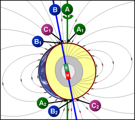
Schematic diagram of the Earth
- A = Earth's axis of rotation (marked with a green line)
- A1 A2 = the geographical poles - the points at which the axis of rotation "cuts" the axis of rotation of the earth.
- The outer core (liquid) (marked in gray) - a layer on Earth where the magnetic field is formed, according to the dynamo theory.
- B = Bipolar Axis (marked with a blue line) - The bipolar magnetic axis, which simulates a kind of magnetic rod, the northern part of which is a magnet that is physically considered "southern" (marked with S = South = South), while its southern part Is considered "North" (N = North = North) physically. Today, the angle between this axis and the axis of rotation of the Earth is 11.3 °.
- B1 B2 = the geomagnetic poles - the points at which the bipolar axis "cuts" the earth's surface.
- Magnetic field lines (thin black lines) - describe the direction of the magnetic field outside the nucleus.
- C1 C2 = The magnetic poles - the points at which the magnetic field lines (marked with black lines) are perpendicular to the Earth (an angle of 90 ° exactly at ground level). The magnetic poles do not overlap with the geomagnetic poles.
Description
| Description | A=Geographic poles, B=Geomagnetic poles, C=Magnetic poles |
| Date | |
| Source | Travail personnel |
| Auteur | DMY |
Conditions d’utilisation
Moi, en tant que détenteur des droits d’auteur sur cette œuvre, je la publie sous les licences suivantes :

|
Vous avez la permission de copier, distribuer et modifier ce document selon les termes de la GNU Free Documentation License version 1.2 ou toute version ultérieure publiée par la Free Software Foundation, sans sections inaltérables, sans texte de première page de couverture et sans texte de dernière page de couverture. Un exemplaire de la licence est inclus dans la section intitulée GNU Free Documentation License. |
Ce fichier est disponible selon les termes de la licence Creative Commons Attribution 3.0 Non transposée.
- Vous êtes libre :
- de partager – de copier, distribuer et transmettre cette œuvre
- d’adapter – de modifier cette œuvre
- Sous les conditions suivantes :
- paternité – Vous devez donner les informations appropriées concernant l'auteur, fournir un lien vers la licence et indiquer si des modifications ont été faites. Vous pouvez faire cela par tout moyen raisonnable, mais en aucune façon suggérant que l’auteur vous soutient ou approuve l’utilisation que vous en faites.
Vous pouvez choisir l’une de ces licences.
Historique du fichier
Cliquer sur une date et heure pour voir le fichier tel qu'il était à ce moment-là.
| Date et heure | Vignette | Dimensions | Utilisateur | Commentaire | |
|---|---|---|---|---|---|
| actuel | 13 novembre 2007 à 11:11 | | 1 028 × 922 (174 kio) | DMY | |
| 11 novembre 2007 à 22:43 |  | 1 028 × 922 (211 kio) | DMY | ||
| 11 novembre 2007 à 22:23 |  | 1 018 × 912 (210 kio) | DMY | == Summary == {{Information |Description=A=Geographic poles, B=Geomagnetic poles, C=Magnetic poles |Source=self-made |Date=Nov 3, 2007 |Author= DMY |Permission= |other_versions= }} == Licensing == {{self|GFDL|cc-by-3.0}} |
Utilisation du fichier
La page suivante utilise ce fichier :
Usage global du fichier
Les autres wikis suivants utilisent ce fichier :
- Utilisation sur ar.wikipedia.org
- Utilisation sur ast.wikipedia.org
- Utilisation sur bn.wikipedia.org
- Utilisation sur ca.wikipedia.org
- Utilisation sur cs.wikipedia.org
- Utilisation sur cy.wikipedia.org
- Utilisation sur el.wikipedia.org
- Utilisation sur en.wikipedia.org
- Utilisation sur en.wikibooks.org
- Utilisation sur eu.wikipedia.org
- Utilisation sur he.wikipedia.org
- Utilisation sur ht.wikipedia.org
- Utilisation sur it.wikipedia.org
- Utilisation sur ja.wikipedia.org
- Utilisation sur ko.wikipedia.org
- Utilisation sur mk.wikipedia.org
- Utilisation sur ms.wikipedia.org
- Utilisation sur ne.wikipedia.org
- Utilisation sur nl.wikipedia.org
- Utilisation sur nl.wikibooks.org
- Utilisation sur pl.wikipedia.org
- Utilisation sur pt.wikipedia.org
- Utilisation sur simple.wikipedia.org
- Utilisation sur sr.wikipedia.org
- Utilisation sur uz.wikipedia.org
- Utilisation sur vi.wikipedia.org
- Utilisation sur www.wikidata.org