
Fichier:Beaubassin1755.jpg

Taille de cet aperçu : 790 × 600 pixels. Autres résolutions : 316 × 240 pixels | 632 × 480 pixels | 1 012 × 768 pixels | 1 280 × 972 pixels | 2 560 × 1 943 pixels | 4 434 × 3 366 pixels.
Fichier d’origine (4 434 × 3 366 pixels, taille du fichier : 4,53 Mio, type MIME : image/jpeg)
Ce fichier et sa description proviennent de Wikimedia Commons.
Description
| Description |
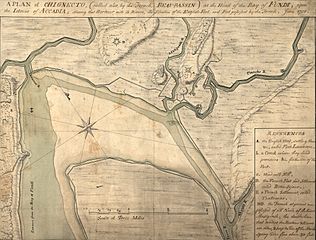
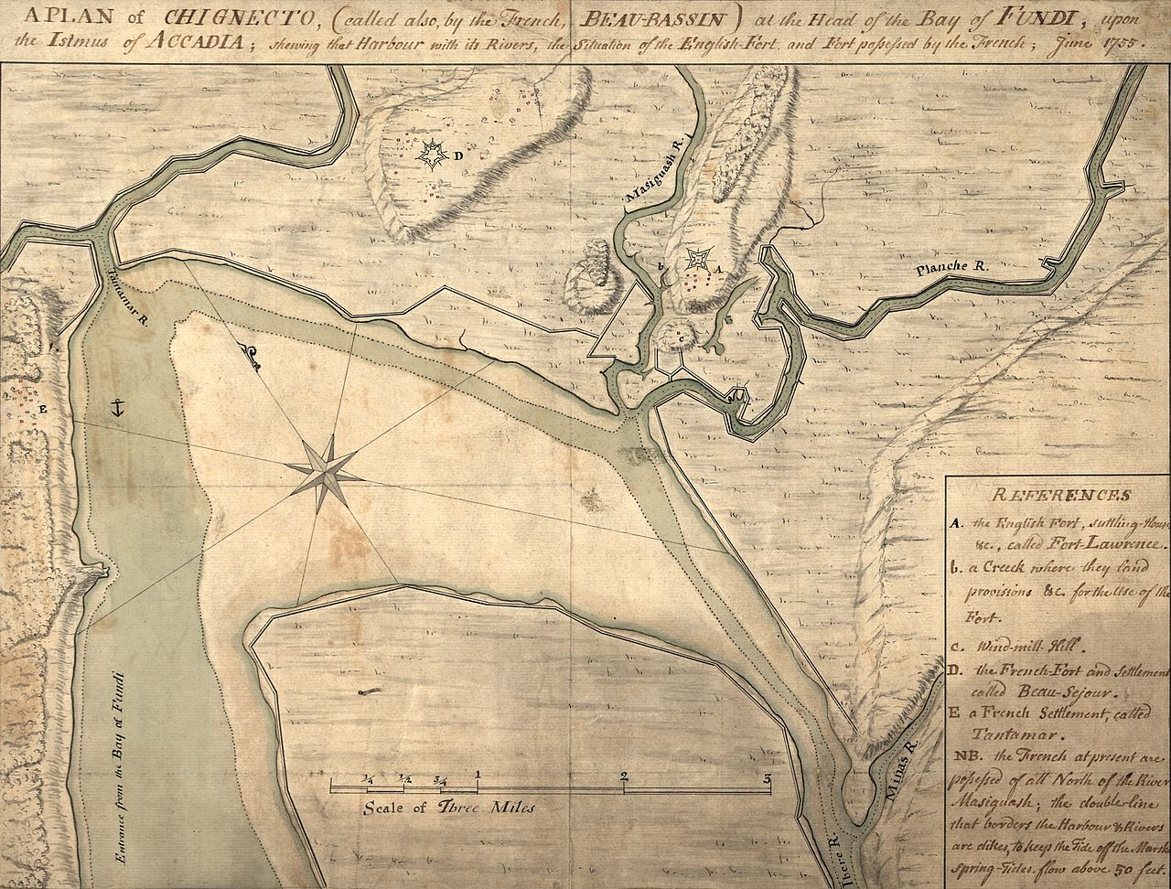
English: A map depicting the Beaubassin region of Nova Scotia in 1755. The area was then on the frontier between British Nova Scotia and French Acadia. The caption reads: A plan of Chignecto (called also by the French Beau-Bassin) at the head of the Bay of Fundi upon the Istmus of Accadia shewing that harbour with its rivers, the situation of the English fort and fort possessed by the French, June 1755.
The image has been cropped from the original to remove a border. |
||
| Date | |||
| Source |
|
||
| Auteur | Auteur inconnu |

Conditions d’utilisation
Ce document est dans le domaine public aux États-Unis. Ceci s'applique aux travaux des États-Unis où le copyright a expiré, souvent parce que sa première publication s'est produite avant le 1er janvier 1929. Voir cette page pour davantage d'explication.
|
 | |
 |
Cette image peut ne pas être dans le domaine public en dehors des États-Unis (ceci s'applique particulièrement au Canada, en Chine (pas Hong Kong, Macao, ni Taïwan), en Allemagne ou en Suisse). Le créateur et l'année de la publication sont l'information essentielle et doivent être fournis.
|
Historique du fichier
Cliquer sur une date et heure pour voir le fichier tel qu'il était à ce moment-là.
| Date et heure | Vignette | Dimensions | Utilisateur | Commentaire | |
|---|---|---|---|---|---|
| actuel | 11 juillet 2009 à 02:16 | | 4 434 × 3 366 (4,53 Mio) | Magicpiano | {{Information |Description={{en|1=A map depicting the w:Beaubassin region of w:Nova Scotia in 1755. The area was then on the frontier between British Nova Scotia and French w:Acadia. The caption reads: A plan of [[w:Isthmus of Chignecto|C |
Utilisation du fichier
Les 2 pages suivantes utilisent ce fichier :
Usage global du fichier
Les autres wikis suivants utilisent ce fichier :
- Utilisation sur en.wikipedia.org
- Utilisation sur it.wikipedia.org
- Utilisation sur ja.wikipedia.org