
Fichier:Somalia map states regions districts.png

Taille de cet aperçu : 582 × 600 pixels. Autres résolutions : 233 × 240 pixels | 466 × 480 pixels | 952 × 981 pixels.
Fichier d’origine (952 × 981 pixels, taille du fichier : 262 kio, type MIME : image/png)
Ce fichier et sa description proviennent de Wikimedia Commons.
Description
| Description |
Afrikaans: Hierdie kaart toon die state, streke en distrikte van Somalië, sowel as die huidige situasie in Somalië.
العربية: هذه خريطة تبين الدول والمناطق والمقاطعات في الصومال، وكذلك الوضع الراهن في الصومال.
Azərbaycanca: Bu harita dövlətlərin, regionların, Somali və rayonlarında, eləcə də Somali cari vəziyyət göstərir.
Беларуская: На карце паказаны дзяржавы, рэгіёнаў і раёнаў Самалі, а таксама бягучай сітуацыі ў Самалі.
Български: Тази карта показва държави, региони и области на Сомалия, както и на настоящата ситуация в Сомалия.
Català: Aquest mapa mostra els estats, regions i districtes de Somàlia, així com la situació actual a Somàlia.
Čeština: Tato mapa ukazuje státy, regiony a okresy Somálska, jakož i aktuální situaci v Somálsku.
Cymraeg: Mae'r map hwn yn dangos y dywed, rhanbarthau, ac ardaloedd o Somalia, yn ogystal â'r sefyllfa bresennol yn Somalia.
Dansk: Kort over regioner og distrikter i Somalia, samt hvilke af disse områder som kontrolleres af diverse selv-udråbte "stater". Desuden er angivet områder i nabolandene med somalisk bosætning.
Deutsch: Diese Karte zeigt die Länder, Regionen und Bezirke von Somalia sowie die aktuelle Situation in Somalia.
Ελληνικά: Αυτός ο χάρτης δείχνει τα κράτη, τις περιφέρειες και περιοχές της Σομαλίας, καθώς και την τρέχουσα κατάσταση στη Σομαλία.
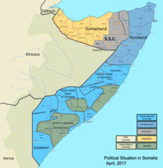
English: This map shows the states, regions, and districts of Somalia, as well as the current situation in Somalia.
Esperanto: Ĉi tiu mapo montras la ŝtatoj, regionoj kaj distriktoj de Somalio, tiel kiel la aktuala situacio en Somalio.
Español: Este mapa muestra los estados, regiones y distritos de Somalia, así como la situación actual en Somalia.
Eesti: See kaart näitab riikide, piirkondade ja linnaosade Somaalia, samuti praegune olukord Somaalias.
Euskara: Mapa honek Somaliako estatu, eskualde eta barrutiak erakusten ditu, hala nola egungo egoera Somalian.
فارسی: این نقشه نشان می دهد ایالات، مناطق، و مناطق سومالی، و همچنین وضعیت کنونی در سومالی است. Suomi: Tämä kartta näyttää valtioiden, alueiden ja piirien Somalian, samoin kuin nykyinen tilanne Somaliassa.
Français : Cette carte montre les Etats, les régions et les districts de la Somalie, ainsi que la situation actuelle en Somalie.
עברית: מפה זו מציגה את מדינות, אזורים ומחוזות של סומליה, כמו גם את המצב הנוכחי בסומליה.
Magyar: Ez a térkép mutatja az államok, régiók és körzetek Szomália, valamint a jelenlegi helyzet Szomáliában.
Bahasa Indonesia: Peta ini menunjukkan negara, daerah, dan distrik Somalia, serta situasi saat ini di Somalia.
日本語: このマップは、状態、地域、ソマリアの地区と同様に、ソマリアの現状を示しています。
한국어: 이지도는 국가, 지역 및 소말리아의 지구뿐만 아니라 소말리아에서 현재 상황을 보여줍니다.
Nederlands: Deze kaart geeft de staten, regio's en districten van Somalië, evenals de huidige situatie in Somalië.
Norsk bokmål: Dette kartet viser stater, regioner og distrikter i Somalia, samt den nåværende situasjonen i Somalia.
Polski: Ta mapa pokazuje stany, regiony i okręgi z Somalii, a także aktualną sytuację w Somalii.
Português: Este mapa mostra os estados, as regiões e os distritos da Somália, assim como a situação corrente no pais.
Română: Această hartă indică statele, regiunile, districtele din Somalia precum și situația curentă din această țară.
Русский: На карте показаны государства, регионы и районы Сомали, а также текущая ситуация в Сомали.
Srpskohrvatski / српскохрватски: Ova mapa prikazuje država, regiona, okruga i Somaliji, kao i trenutne situacije u Somaliji. / Ова мапа приказује држава, региона, округа и Сомалији, као и тренутне ситуације у Сомалији.
Українська: На карті показані держави, регіонів і районів Сомалі, а також поточну ситуацію в Сомалі.
Tiếng Việt: Bản đồ này hiển thị các bang, khu vực, và huyện của Somalia, cũng như tình hình hiện nay ở Somalia. |
|||
| Date | ||||
| Source | Travail personnel | |||
| Auteur | Ingoman (James Dahl) | |||
| Autres versions |
|


Conditions d’utilisation
| Moi, propriétaire des droits d’auteur sur cette œuvre, la place dans le domaine public. Ceci s'applique dans le monde entier. Dans certains pays, ceci peut ne pas être possible ; dans ce cas : J’accorde à toute personne le droit d’utiliser cette œuvre dans n’importe quel but, sans aucune condition, sauf celles requises par la loi. |
Historique du fichier
Cliquer sur une date et heure pour voir le fichier tel qu'il était à ce moment-là.
| Date et heure | Vignette | Dimensions | Utilisateur | Commentaire | |
|---|---|---|---|---|---|
| 10 septembre 2014 à 03:19 |  | 3 000 × 3 169 (1,73 Mio) | AcidSnow | WTF, piracy has been died for years now. | |
| 10 septembre 2014 à 02:59 |  | 3 000 × 3 169 (1,74 Mio) | AcidSnow | Hiran has been entirely liberated from the terrorist by the Somali Army. I also fixed separatist control of some northern regions of Somalia. | |
| 7 juillet 2014 à 02:14 |  | 3 000 × 3 169 (943 kio) | Spesh531 | updates in somaliland and khatumo | |
| 27 mai 2014 à 07:53 |  | 3 000 × 3 169 (950 kio) | Spesh531 | update 24 may 2014 | |
| 26 mars 2013 à 21:52 |  | 3 000 × 3 169 (1,24 Mio) | Wolfiukas | Government is in full control of Hudur http://somaliamediamonitoring.org/march-25-2013-morning-headlines/ | |
| 22 mars 2013 à 17:36 |  | 3 000 × 3 169 (1,24 Mio) | Wolfiukas | Hudur under Al-Shabaab control. http://www.monitor.co.ug/News/World/Al-Shabaab-renews-offensive-in-southern-Somalia/-/688340/1724270/-/eq7hgmz/-/index.html Kismayo - capital of Azania http://somaliamediamonitoring.org/march-22-2013-morning-headlines/ | |
| 27 février 2013 à 18:50 |  | 3 000 × 3 169 (1,24 Mio) | Wolfiukas | Buur Hakaba under FG control http://somaliamediamonitoring.org/ | |
| 13 décembre 2012 à 07:40 |  | 3 000 × 3 169 (1,24 Mio) | Turkmenistan | http://shabelle.net/dowladda-oo-la-wareegtay-gacan-ku-heynta-jowhar-iyo-mahaday-shdhexe/ The new talks about the fall of Jowhar and Mahaday, a town in the outskirts of Jowhar. Full New: Jowhar (Sh.M.Network)— Ciidamada dowladda Soomaaliya iyo kuwa ... | |
| 9 décembre 2012 à 15:56 |  | 3 000 × 3 169 (1,24 Mio) | Wolfiukas | jowhar to federal government. xudun to somaliland. | |
| 13 novembre 2012 à 18:28 |  | 3 000 × 3 169 (913 kio) | Wolfiukas | Reverted to version as of 17:22, 17 October 2012 |
Utilisation du fichier
Les 17 pages suivantes utilisent ce fichier :
Usage global du fichier
Les autres wikis suivants utilisent ce fichier :
- Utilisation sur af.wikipedia.org
- Utilisation sur ar.wikipedia.org
- Utilisation sur azb.wikipedia.org
- Utilisation sur ca.wikipedia.org
- Utilisation sur ckb.wikipedia.org
- Utilisation sur cs.wikipedia.org
- Utilisation sur cy.wikipedia.org
- Utilisation sur de.wikipedia.org
- Utilisation sur el.wikipedia.org
- Utilisation sur en.wikipedia.org
- Transitional Federal Government of Somalia
- Al-Shabaab (militant group)
- Battle of Bargal (2007)
- File talk:Somalia map states regions districts.png
- Wikipedia:Graphics Lab/Map workshop/Archive/May 2009
- United Nations Security Council Resolution 1587
- 2012 timeline of the Somali Civil War
- Wikipedia:Graphics Lab/Map workshop/Archive/May 2012
- User:Mir Almaat 1 S1/Islamic Emirate of Somalia
- 2013 in Somalia
- Wikipedia:Graphics Lab/Photography workshop/Archive/Jul 2013
- Wikipedia:Graphics Lab/Map workshop/Archive/Sep 2013
- List of conflicts in Somalia
- Wikipedia:Graphics Lab/Map workshop/Archive/Apr 2014
- Battle of Leego (2015)
- Battle of El Adde
- Utilisation sur en.wikinews.org
- Utilisation sur en.wikivoyage.org
- Utilisation sur eo.wikipedia.org
- Utilisation sur es.wikipedia.org
- Utilisation sur et.wikipedia.org
- Utilisation sur eu.wikipedia.org
Voir davantage sur l’utilisation globale de ce fichier.